11 February 2011

36th CEOS Newsletter Published

This week the 36th Committee on Earth Observing Satellites (CEOS) Newsletter was published, and can be found linked from the CEOS webpage, here. Articles in this edition include:

  • A wrap-up from INPE as the 2010 CEOS Chair
  • A summary of CEOS Strategic Implementation Team (SIT) activities
  • Announcement of the CEOS publication Science, Satellites and Society
  • Announcement of the WCRP Open Climate Science conference, 24-28 October 2011, Denver CO, US
  • An update on GEOSS implementation
  • A note from the CEOS Executive Officers
  • A recap of CEOS presence at GEO-VII
  • Updates from the CEOS Working Groups
  • And a message from ASI, the 2011 CEOS Chair

More information on CEOS can be found at www.ceos.org.

03 February 2011

ISU Southern Hemisphere Summer Space Program - Paths to Progress

As noted in a previous post, the International Space University's (ISU) inaugural Southern Hemisphere Summer Space Program (SHS-SP) was held in Adelaide in January 5th to February 4th, 2011. The program consisted of 43 participants from nine different countries spending an intensive month studying all aspects of space and space activities. Additional information and links to material discussed and presented can be found on the program homepage, here.

The program culminated with the presentation of the group's White Paper which focused on:

"...[proposing] space-related policies and strategies to serve current and future social and economic needs in Southern Hemisphere States."


After considerable discussion, the group focused their report on three goals that were also linked to the UN's Millenium Development Goals:
  1. Realising Southern capabilities.
  2. Developing Earth observation capabilities.
  3. Promoting tele-health and tele-education.
Their report contained six key recommendations related to these goals.
  1. Exploit the natural and geographic advantages of the Southern Hemisphere.
  2. Establish a Regional Space Industry Association.
  3. Collaborate on Earth observation systems.
  4. Cooperate on EO data and product dissemination.
  5. Develop expertise and infrastructure to ensure optimal use of available EO and GIS solutions.
  6. Invest in tele-health and tele-education.
The executive summary and full report are available for download from the program White Paper website.


02 February 2011

SIAA Key Dates and Notes


Below are a few notes on current activities and upcoming events from SIAA Chair Brett Biddington.

1. The first SIAA Executive Council (EC) meeting will be held in Sydney on Thursday 24th February. The EC will elect the office holders at the meeting. Michael Davis will be sending to you all more details of the meeting - timing, venue and agenda in the next few days. ALL members are invited to attend the meeting.

2. Please put a diary note against 31st March, the likely date for the first Space Industry Innovation Council meeting for 2011. The meeting is scheduled to be held in Sydney and the afternoon session will be some form of open forum. The details of timing, venue, structure and sought outcomes will be available closer to the date.

3. Last week, the UK Ministers for Defence and Foreign Affairs visited Australia and held counterpart talks with Ministers Smith and Rudd. The links below will take you to the communiqués issued at the conclusion of the talks. As with last November's AUSMIN talks, space figures prominently. At some point these policy developments may be expected to turn into business opportunities.

AUKMIN 2011 documents:

4. The floods and recent wild weather, and its aftermath, underscores the important, perhaps critical, role that Earth observation satellite systems play in the planning, warning, recovery and reconstruction phases of disasters. (See related recent SIAA blog post.) Over the coming months, it seems likely that the Commonwealth and various State Governments will receive many offers of help satellite data providers of all sorts. It will be important for the space industry to present a balanced and realistic picture of the potential role of Earth observation satellites in future disaster preparation, response, and recovery.

5. Recently a space security meeting was held in Delhi, India, co-organised by the Secure World Foundation, The Stockholm International Peace Research Institute, the Observer Research Foundation, and the Jawaharlal Nehru University. More information on discussions at the meeting can be found here.

6. It is anticipated that the fourth and final round of the ASRP will be opened in mid-late February. Applications will close six weeks later and it is expected that successful applicants will be announced in May. It is possible that DIISR may seek a small amount of funding in the 2011 budget for follow-on rounds of the ASRP, however this will be dependant on the economy and the PM's determination to balance the budget in 2012-13.

7. The ISU/UniSA Southern Hemisphere - Summer Space Program (SH-SSP), is concluding this week in Adelaide. Several SIAA members have been involved with the program, which is generating an amazing amount of energy and enthusiasm and shows a great deal of promise for the future.

In summary, in this Year of the Rabbit, the Chinese curse, "May you live in interesting times" has never seemed more prescient and relevant. Risk breeds opportunity. Played right, we have an opportunity this year to advance the interests of Australia's space industry substantially.

28 January 2011

Earth Observation Satellites and the 2010/2011 Australian Floods

Back in Mid 2010, the Ocean Surface Topography Mission (OSTM) / Jason 2 satellite, a combined U.S. / French satellite, detected minute changes in the Pacific ocean. Subtle as they were, taken across the Pacific ocean, they added up to a major meteorological change. A new episode of La Niña, where the sea surface temperature across the equatorial Eastern Central Pacific Ocean is lower than normal by 3-5 °C was developing, leading to an increased likelihood of above average rains in Australia.


An Ocean Surface Topography Mission (OSTM)/Jason-2 satellite image of the Pacific Ocean, based on the average of 10 days of data centred on Dec. 26, 2010. (Image Source: NASA)

As 2010 progressed, this meteorological feature made true to the early predictions, and from the U.S. GOES-10, U.S. GOES-12, Japanese MTSAT-1R and Chinese Feng Yun-2 Geostationary Satellites, together with the U.S. NOAA (12 to 18) and Chinese Feng Yun-1 polar orbiting weather satellites, accurate and up to date satellite weather forecast information was provided to the Australian Bureau of Meteorology about how much rain might be ahead.

In the days in late December 2010 and early January, things started to become critical, as an already soaked Australian land, was forecast to have more major rainfall, with predicted flooding. Digital terrain models, which are heavily derived from EO Satellite data, was overlayed by the predicted rainfall, showing very quickly the extent of the impending disaster.

January 10, 2011 Multi-Satellite Precipitation Analysis (MPA) based on data from the NASA / JAXA Tropical Rainfall Measuring Mission (TRMM) (Image Source: NASA)

On the 3rd of January 2011, Emergency Management Australia requested that the U.S. Geological Survey activate the “International Charter Space and Major Disasters” formally requesting that all nations who have signed the treaty provide as much imagery as possible to help with the crisis at hand. The Charter is contributed to by 15 space agencies with 20 satellites available, however as Australia is not a member, and has no satellites, it must rely on the United States for assistance. Over the next few weeks, imagery from a vast array of nations was provided to Australia, particularly from the United States, Europe and Canada.


Flooding around Rockhampton on the 7th of January, 2011 – captured by the Advanced Spaceborne Thermal Emission and Reflection Radiometer (ASTER) on NASA’s Terra satellite. The image includes both infrared and visible light to increase the contrast between muddy floodwater and brown earth. (Image Source: NASA)

Before and After imagery from the Italian Space Agency. Image processed by the Geodesy and Earth Observing Systems Group (GEOS), UNSW. Supported by UNSW, LPMA and CRCSI. (Image Source: BBC)


Envisat SAR image of flooding near Rockhampton in Queensland , Jan 2011 (Image Source: ESA)


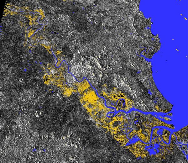
A RADARSAT-2 Flooding “Change Detection” image, showing the flooding on the 7th of January – highlighting the flooding in Yellow. (Image Source: Canadian Space Agency)

Post flooding, EO Satellites have been used to map the damage, map the changes in the terrain, map soil moisture as well as assess things like potential for damage to the Great Barrier Reef from the run-off.

Soil Moisture across Australia as measured by the ESA Soil Moisture and Ocean Salinity (SMOS) Satellite Mission (Image Source: BBC)

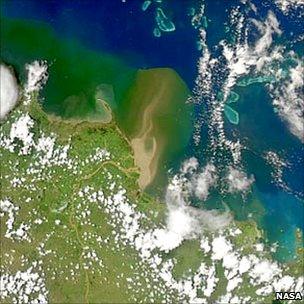
Floodwaters pouring out of Queensland’s swollen rivers threating the Great Barrier Reef (Image Source: NASA)

It has been estimated that the flooding has covered over 75% of the state of Queensland, in an area roughly the size of France and Germany combined, leading to one of Australia’s biggest environmental disasters in living memory.

Earth Observation data has played a key role in helping predict and monitor the recent floods in Australia. In crisis, Earth Observation satellites can, and do save lives and damage, offering advanced warning and prediction of disasters before the arrive, impact when they arrive, and assistance to recovery when they have passed.

Australia is critically reliant on Earth Observation satellites and the data they provide, and yet Australia is also totally reliant on other nations to provide this data at all times, and is not a contributor or member of the International Charter Space and Major Disasters, despite it helping us in our time of need. In the wake of the recent flooding, Australia needs to review the crucial role that Earth Observation Satellite data played, and decide what future role it will play in Australia, and whether we should be the next Country to join the International Charter Space and Major Disasters.

21 January 2011

APRSAF Launches Climate R3 Initiative

The Asia-Pacific Regional Space Agency Forum (APRSAF) recently held its annual meeting (APRSAF-17) in Melbourne, Australia. The headline outcome was the announcement of an APRSAF initiative for a Regional Readiness Review for Key Climate Missions (aka Climate R3).

The objectives of Climate R3 are to determine the ability of APRSAF countries and institutions to benefit from the data and information that will be provided by selected climate-related satellite missions in coming years; and to raise awareness of the benefits of these missions and their expected in-country applications for APRSAF governments and societies. The emphasis is on applications of space-derived information, and not on satellite systems per se; and identifying future measures to enhance regional capacity to exploit the significant investment being planned worldwide in the coming decade.

A Climate R3 pilot phase is being planned for 2011, under the leadership of the Australian and Japanese EO Working Group Co-Chairs from APRSAF-17. Contributions from other enthusiastic parties are also being welcomed, specifically from countries with a strong interest in the selected domains for study. As a part of the pilot phase, the focus will be on one or two high priority measurement classes, for example precipitation and land cover, and if the pilot proves useful the intention would be expand the measurement classes covered in future.


Regional workshops will take place in the 2011 to showcase results of early studies, and to explore opportunities and obstacles, including the potential for data up-take. This will be followed by a progress report on the pilot phase to be delivered to APRSAF-18, as well as a dedicated workshop held to deliver the main conclusions and recommendations on the way forward for the APRSAF Climate R3 effort.

The study of the climate is one the key challenges for humanity in the coming decades, and it is hoped that ARPSAF's Climate Rinitiative will begin to enable greater regional access to, and utilisation of space-derived data and data products. The initiative also represents a good opportunity for members of the Australian and APRSAF space applications community to demonstrate the benefit of space-based information services for society.

About APRSAF: APRSAF was established in 1993 to enhance space activities in the Asia-Pacific region, and provides a forum for space agencies, governmental bodies, and international organisations, such as the United Nations, as well as companies, universities and research institutes from over 30 regional participants take part in space-related dialogue covering issues of relevance in the Asia-Pacific region.

About GEO and GEOSS: The Group on Earth Observations (GEO) is coordinating efforts to build a Global Earth Observation System of Systems (GEOSS).

07 December 2010

Importance of satellites highlighted at climate summit

Although finding a successor to the Kyoto Protocol is a major item on the agenda at the 2010 UN Climate Change Conference in Cancun, Mexico, delegates are also working hard to establish an international climate monitoring system.

In order to effectively respond to climate change challenges, decision-makers need scientifically based climate knowledge. It is the job of the Subsidiary Body for Scientific and Technological Advice (SBSTA) to make sure that the Conference of the Parties (COP) gets the very best expert advice possible.

Speaking at a SBSTA plenary session in Cancun on Wednesday, Prof. Adrian Simmons, Chairman of the Global Climate Observing System (GCOS) Steering Committee, explained the progress made in climate observations over the last five years and noted the need for improved coverage. According to GCOS, which provides reliable and comprehensive data on the total climate system to the UN Framework Convention on Climate Change, space agencies have improved their observational capabilities and are increasingly meeting the needs identified for data reprocessing.Get the full story on the ESA website: http://www.esa.int/SPECIALS/Space_for_our_climate/SEMTBJOWXGG_0.html

Australia hosts APRSAF

Australia recently played host to the 17th APRSAF meeting in Melbourne. The theme of the meeting was ' the role of space technology and industry in addressing climate change'.

The Asia-Pacific Regional Space Agency Forum (APRSAF) was established in 1993 to enhance space activities in the Asia-Pacific region. Space agencies, governmental bodies, and international organizations, such as the United Nations, as well as companies, universities and research institutes from over 30 regional participants take part in APRSAF, the largest space-related conference in the Asia-Pacific region. With increasing attendance of high ranking officials, furthermore, APRSAF offers opportunities to discuss international cooperation for space activities in concrete terms.

APRSAF-17 included four working groups: Earth Observation (EO), Communication Satellite Applications (CSA), Space Education and Awareness (SEA), and Space Environment Utilization (SEU), to share information about the activities and the future plans of each country and region in the respective areas. APRSAF also supports the establishment of international projects as solutions for common issues such as disasters and environmental protection so that the participating parties can realize cooperation. Workshops on SAFE (Satellite Applications for Environment) and on GNSS were also arranged in the margins of the meeting in Melbourne.

The meeting was well attended by APRSAF participating countries and Australia successfully proposed the initiation of a new framework, consistent with the theme of APRSAF-17, aimed at developing regional readiness for key forthcoming climate satellite missions. Details of this initiative (Climate R3) will follow...

More details on APRSAF here: http://www.aprsaf.org/